Sine City:
San Marcos Creek Development Project
Project Description:
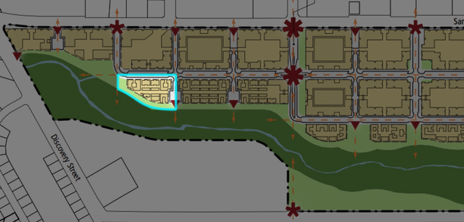
Sine city was a project about urban planning, architecture and trigonometry. In this project we learned about the San Marcos Creek development project. This real project from the City of San Marcos aims to revitalize the space between discovery street and San Marcos Blvd. This land stretched from HTHNC to the Best Buy/WinCo shopping center. Currently, the space is composed of vacant lots, small businesses, "strip malls" and mobile homes. The vision of the city of San Marcos is to turn this mostly private and inaccessible land into a new downtown for San Marcos. This downtown will be split up into 38 blocks, or 38 different parcels of land.
In this project, we were split up into groups and assigned a specific parcel of land to design. We studied the requirements set forth in the "San Marcos Creek Specific Plan", surveyed our land, designed the buildings that would go on the land and arranged all of our buildings on our land. I had to learn a variety of new skills including adobe illustrator, reading Sun Path diagrams, trigonometry, principles of architecture and urban planning.
Process:
This project was made up of several components. I progressed in my understanding of surveying, urban planning and architecture/design.
In the first part of this project we surveyed the space that we were going to be developing by taking a day to go out to our plot of land, see what was there and make measurements. We did a site analysis and a site survey of our plot of land. In our analysis we took into account several natural and made made features that created the physical, and socioeconomic landscape in which we would be developing.
SURVEYING: Natural Features
Our plot of land was made up of a vacant parking lot and the creek. There was no vegetation in the parking lot except for a few small shrubs. However, the parking lot was surrounded by vegetation on the west and south sides. The vegetation on the west side was mostly grasses, shrubbery with several cottonwood and palm trees by a small stream coming out of a drainage ditch. The vegetation on the south side resembled a riparian habitat with some thick ice plant ground cover, tall grasses and cottonwood trees. There was also a large pine tree right next to the south fence.
There was some common wildlife currently living on our plot of land. In the parking lot there were many common birds including house finches, sparrows and yellow warblers. Crows perched in the eucalyptus trees on the other side of the creek and we heard many small frogs in and around the creek. Near the chaparral covered west fence, we saw gophers, rabbits and squirrels. We found no endangered species nor did we find any record on endangered species in that area.
The Climate on our plot of land was the same as the rest of San Marcos with an average of 16 inches of rain, 0 inches of snow and 265 sunny days per year
The average July high is 88 degrees and the average January low is 38 degrees. Also, because the bulk of our land was in direct sunlight. There was very limited shade. There were 5 shady trees by the creek, most of them right next to the water. Our land had an overall dry temperature, low humidity. LINK
SURVEYING: Man Made Features
There are currently no sanitary/water utilities on the property. and no existing water/gas pipes that could be used in our buildings. However, there are 2 large (3ft diameter) water pipe/water meter cover. Only 1 appears to be operational. It is in the middle of the parking lot. Our site is currently being used as a privately owned parking lot. However, the parking lot is always vacant and there is no clear owner. All existing structures are in need of renovation. Parking lot is crumbling and not taken care of. The fences are rusting, full of holes and falling down. There is no population our land.
The adjacent lot has the EZ living mobile homes. There are 78 mobile homes in EZ living mobile home park. The housing development behind our land (on Discovery Street) has over 100 residences. The 92078 zip code has a 65% (1,882 people) hispanic population, 33.9% (984 people) white population, 0.3% (9 people) American Indian population. In the 92078 zip code, 17.1% of the population is below the poverty line, the median age is 36 years old, unemployment is at 5.96% (City-Data) and 26.7% of people have a college degree (ZipWho.com).
When on San Marcos Blvd, our plot of land is hard to see by all modes of transportation. The bulk of the land is hidden by a wall of trees near a creek that has formed from a drainage ditch. The only way to see the property is to look through the gate. Drivers, cyclists and pedestrians can see the property through the gate but tend to ignore it because there is nothing to look at, the space is not a useful shortcut and it is completely surrounded by a fence.
Below are images of my groups parcel of land:
SURVEYING MATH
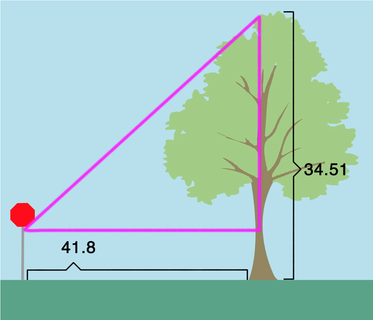
Pine Tree Height
Isaiah measured the angle of pine tree from approximately 41.8 ft away. The angle measured was 35 degrees. Isaiah’s eye level is at 5.25 ft so we will need to add that to the height.
tan(35)=opp/41.8
opp=41.8*tan(35)
opp=29.26
29.26+5.25= 34.51
so… tree height=34’6”
Pine Tree Height
Isaiah measured the angle of pine tree from approximately 41.8 ft away. The angle measured was 35 degrees. Isaiah’s eye level is at 5.25 ft so we will need to add that to the height.
tan(35)=opp/41.8
opp=41.8*tan(35)
opp=29.26
29.26+5.25= 34.51
so… tree height=34’6”
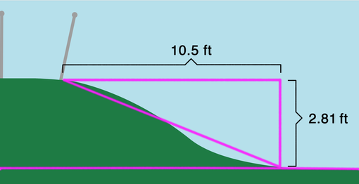
Iceplant Slope Height
Length and height of slope on iceplant
slope angle (from 6in off the ground)= 15 degrees.
flat distance from top of incline to bottom approximately= 10.5 ft
tan(15)=opp/10.5
opp= 10.5*tan(15)
opp= 2.81 ft = 2 ft. 10 in. + 6in (height of angle protractor)
slope height= 3 ft. 4 in.
URBAN PLANNING
After surveying the space, I came up with an initial plan of how to design the space. I took into account many of the physical(natural and manmade) and socioeconomic features in the space when creating my design. I then reviewed the San Marcos Specific Plan, mostly chapters 3 and 6, to create a building and design my plot of land in accordance with all of the regulations.
Although our site is currently in a state of disrepair, with old mobile homes and an untamed riparian habitat, it presents us with the opportunity to bring new life to an area of lower income households. The surrounding area is full of mobile home parks out of site from San Marcos Blvd, The natural, cultural and aesthetic features at and surrounding the site are perfect for creating a new development. The majority of our land is flat and already paved, meaning that we have a nice foundation for our construction. We believe that the surrounding population will benefit from our new development plan.
We plan to 1) open up the views of the space by removing the majority of the shrubbery by the road and to the west of our land, 2) build multi level apartment complexes designed for family living 3) create a semi-public space behind our apartments that will fulfill San Marcos' vision of a creekside park. We also believe that a new, residential complex of buildings will help with those displaced by the rest of the development (such as the EZ living residents). Because most of the people who would be displaced would have low socioeconomic status, we want these apartments to be affordable. In order for the apartments to be affordable they can't be too large. I am going to try to create apartments about 1000 sq ft large. We plan on creating a safe, lively and affordable environment that the current residents in the area will be able to benefit from.
The regulations for the "West End" of the San Marcos Creek development, where my group's parcel of land was included:
- 1:1.25 floor ratio
- Residential permitted everywhere, including ground floor.
- Minimum building height: 2 stories or 25 feet.
- Maximum building height 5 stories or 65 feet.
- Buildings located adjacent to both public open space (e.g., plazas, parks, and the Creekside Promenade) and public streets should face the street and the public space
- Water features should be part of the building.
- Buildings must be stepped back beyond the third story to make them seem less huge.
- Entrance must be clearly visible and easily accessible from the street and the San Marcos Creek park
ARCHITECTURE & DESIGN
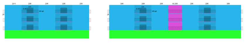
ELEVATION VIEW MEASUREMENTS:
- Floor height: 10 ft
- Balcony railing height: 4 ft
- Balcony length: 20ft
- SIDE VIEW (100 x 40 ft):
- Distance from building edge to balcony: 20ft
- Front View (156.25 x 40 ft):
- Distance from building edge to balcony: 30ft
- Distance from balcony to elevator space: 20ft
- Distance from building edge to Balcony: 20ft
PLAN VIEW LEVELS 1-3 MEASUREMENTS:
- Apartment (20 x 50 ft)
- Balcony: 20 x 4 ft
- Kitchen: 10 x 20 ft
- Bedroom (x2): 10 x 17 ft
Our building meets all of the requirements of the San Marcos Specific plan. Our building is on the West End sector of the development. Residential was permitted everywhere. The building’s facade and entrance faces San Marcos Blvd, in accordance with the Specific Plan.
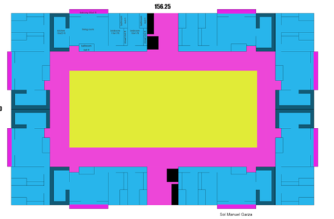
We were required to build between 25 feet/2 stories and 60ft/5 stories. Our building has 3 storeys and an underground parking structure. Because the building is only 3 storeys tall above ground, we are not required to step back any floors. Above ground, the building stands 30’ tall. Each storey is 10’ tall, the average height for a storey in the US. We had a floor ratio of 1.25:1. Because our total land area was approximately 250 x 200 square feet or 50000 square feet, we were allowed to build on 1.25*50000 = 62500 square feet.
Because we were building 4 storeys total, each floor would have to have an area of 62500/4 = 15625 square feet. This uses our floor area ratio to give us the maximum building area permitted. The dimensions of our building are 156.25 feet by 100 feet.
We are not building a solid block of apartments. As the Specific Plan stated, we were supposed to create, a safe, semi-public space on our development. We decided to create a shared courtyard in the middle of the apartment structure. This space is on ground level and is accessible from each apartment. The courtyard’s centerpiece is a 10 foot diameter fountain, our building’s water feature. The courtyard, is a grassy, park-like area for the residents of our apartment building to enjoy.
At first, we wanted the courtyard to be rectangle with proportional sides with ½ of the building’s area. We knew that ½ of the area of 1 floor was: 15625/2 = 7812.5, and that the sides would have to be proportional to 100 feet and 156.25 feet. Below are my calculations:
KNOWNS:
- x*y = 7812.5 (area)
- y = z(156.25)
- x = z(100)
CALCULATIONS:
x/100 = z
y/156.25 = z
x = 100(y)/156.25 (now we can substitute this for x in our original equation.)
100(y)/156.25 * y = 7812.5
100(y^2) = 156.25 * 7812.5
100(y^2) = 1220703.125
y^2 = 12207.03125
(x,y) = (70.70,110.50)
We need our smaller rectangle to be exactly in the center of our larger rectangle.
We know that the y of the larger rectangle is 156.25 and that the y of the smaller rectangle is 110.5:
156.25 - 110.5 = 45.75
45.75/2 = 22.875 = 22’10.5”
The x should result in the same space:
100 - 70.70 = 29.3
29.3/2 = 14.65 = 14’7.8”
… But it doesn’t. So we have a building 22’10.5” wide between the courtyard and the outer wall on the front and back and 14’7.8” from side to side.
This was when I realized that proportional sizing down the courtyard would result in unequal widths for the apartment sizes. This would not be fair to the homeowners and would result in some very thin apartments.
I then decided to simply subtract an equal amount of feet from each side of the building. My only question was how much to subtract. To make an informed decision, I found the average apartment size in the United States: 982 square feet. I decided to make our apartments each 1000 square feet with a length of 50 feet and a width of 20 feet. I subtracted 20ft from each side of the building from the outer wall, leaving a courtyard of 156.25 - 40 = 116.25 feet by
100 - 40 = 60 feet. These dimensions allowed me to make an apartment building with 18 individual apartments total and 6 on each floor.
In accordance to regulation, we have both an elevator (6 feet deep and 7 feet long) and a staircase (4 feet wide and 11 feet long with 17 steps between each floor). Each stair is 7 inches long and 7 inches tall, in accordance to the US guidelines for staircases.
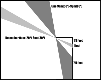
SUN PATH
We utilized our sun path diagram when we had to decide where to put windows on our building. We had created a natural awning from the balconies. Each balcony is 4 feet long and each floor is 10 feet tall. We had to create a window that would be mostly in the shade from the balcony during the summer and mostly in the sun during the winter between 9:00am and 3:00pm. We need to figure out where to put a window so that it absorbs light in December and deflects it in June. Below, are the Polar coordinates (Azimuth and Altitude) for San Marcos California:
- June 21 at 9:00am: Altitude = 50º and Azimuth = 92º
- June 21 at 3:00pm: Altitude = 80º and Azimuth = 92º
- December 21 at 9:00am: Altitude = 20º and Azimuth = 140º
- December 21 at 3:00pm: Altitude = 30º and Azimuth = 200º
Our window that takes into consideration the sun path diagram is tiny. It is merely 1 ft tall and is 1.5 feet from the top of the floor. It works to keep light out in the summer months and let it in in the winter months. However, we realize that we need another window. To avoid creating a second awning, we have decided to add blinds to this larger window so that people can keep the sun out when they want. Below is the location of the window that takes into consideration the sun path.
GOLDEN RATIO
I utilized the golden ratio for the second, larger window. The golden ratio is the relationship: (a+b)/a = a/b = 1.618. Designs that incorporate this ratio are believed to be aesthetically pleasing. We incorporated this ratio into our window design. Our Window is located in front of each bedroom. Each bedroom is 10 feet long and 10 feet tall. I divided our window into slices that would create the golden ratio. These numbers were 6.18 and 3.82. These number fulfill the formula “(a+b)/a = a/b = 1.618.”:
6.18/3.82 = 1.618
(6.18 + 3.82)/6.18 = 1.618
As a result, our window is 3.82 ft away from the end of each wall and is 6.18 x 6.18 feet.
Reflection
My biggest takeaways from this project include the process that architects and urban planners have to go through in order to turn an existing place into something completely new. This process involves a lot of trigonometry, measurement and vision. As I went through all of the steps that it takes to go from concept to creation of our building, I realized how much work it takes to develop a plot of land before construction even begins. I grew as a mathematician during this project by learning how to survey a piece of land using trigonometry to determine lengths of our land. I also learned how to read a sun path chart to determine at what angle the sun will hit a building at any time during the day and how to incorporate the Golden ratio into my design to make it more aesthetically pleasing.
The biggest challenges that I faced involved using Adobe Illustrator. I am very comfortable using photoshop so I tried to make my digital design in photoshop and then just transfer that file into Illustrator. Unfortunately, because Photoshop is a pixel based program and Illustrator is a vector based program, the file did not transfer correctly. I spent many hours trying to get this to work before i realized that I would have to recreate my drawings in Illustrator. Luckily, i had already made all of the measurements in Photoshop so i know how to make each wall and facade feature.
Although transferring the files for the later cutter was challenging, creating the digital design was by far my favorite part of the project. I love being able to integrate art and math by designing and interesting, yet practical building. I also enjoyed the realism of this project. because the San Marcos Creek development is an actual project that is taking place in San Marcos, I was heavily invested in this project from beginning to end.
Exhibition
I enjoyed the exhibition we had because My group and I were able to present our work in a way that really captured all of the work we did. Sometimes exhibitions don't really capture how much work was put into creating the final products, but this one definitely did not have that problem. I showed people the later cut design of our building, I passed out brochures detailing what my apartments are like and the process that it took to create them. I really enjoyed describing the process that my group went through to create our apartment complex as well as describing all of the features of my building and site plan.
I enjoyed the exhibition we had because My group and I were able to present our work in a way that really captured all of the work we did. Sometimes exhibitions don't really capture how much work was put into creating the final products, but this one definitely did not have that problem. I showed people the later cut design of our building, I passed out brochures detailing what my apartments are like and the process that it took to create them. I really enjoyed describing the process that my group went through to create our apartment complex as well as describing all of the features of my building and site plan.
